
Ibrahim Hyderi topographic map
Interactive map
Click on the map to display elevation.
About this map
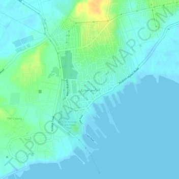
Name: Ibrahim Hyderi topographic map, elevation, terrain.
Location: Ibrahim Hyderi, Karachi, Karāchi District, Sindh, Pakistan (24.78072 67.13431 24.80248 67.14943)
Average elevation: 23 ft
Minimum elevation: -3 ft
Maximum elevation: 98 ft
Other topographic maps
Click on a map to view its topography, its elevation and its terrain.
New Karachi Town
New Karachi Town, New Karachi Sector 5B, North Karachi Sector 5, Karachi, Sindh, Pakistan
Average elevation: 184 ft
Bahria Town
Pakistan > Sindh > Karachi > Bahria Town
Bahria Town, Karachi, Sindh, Pakistan
Average elevation: 417 ft