
Beryozovo topographic map
Interactive map
Click on the map to display elevation.
About this map
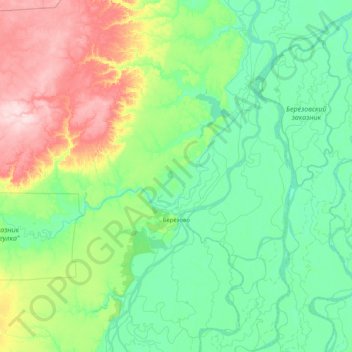
Name: Beryozovo topographic map, elevation, terrain.
Average elevation: 151 ft
Minimum elevation: 7 ft
Maximum elevation: 696 ft
Other topographic maps
Click on a map to view its topography, its elevation and its terrain.
Mount Narodnaya
Russia > Khanty-Mansiysk Autonomous Okrug – Ugra > Beryozovsky District
Mount Narodnaya, Beryozovsky District, Khanty-Mansiysk Autonomous Okrug – Ugra, Ural Federal District, Russia
Average elevation: 4,715 ft
Ural Mountains
Russia > Khanty-Mansiysk Autonomous Okrug – Ugra > Beryozovsky District
Ural Mountains, Beryozovsky District, Khanty-Mansiysk Autonomous Okrug – Ugra, Ural Federal District, Russia
Average elevation: 4,708 ft
Манси
Russia > Khanty-Mansiysk Autonomous Okrug – Ugra > Beryozovsky District
Манси, Beryozovsky District, Khanty-Mansiysk Autonomous Okrug – Ugra, Ural Federal District, Russia
Average elevation: 4,285 ft