
Make a donation
Gear up for your next adventure:
As an Amazon Associate, this site earns from qualifying purchases at no extra cost to you.
Fernvale topographic map
Click on the map to display elevation.
Make a donation
Gear up for your next adventure:
As an Amazon Associate, this site earns from qualifying purchases at no extra cost to you.
About this map
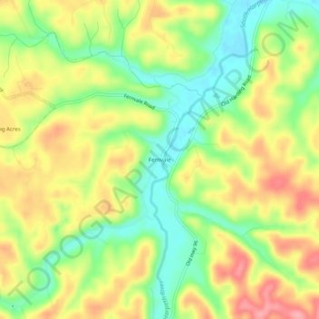
Name: Fernvale topographic map, elevation, terrain.
Location: Fernvale, Williamson County, Tennessee, United States (35.93451 -87.09917 35.97451 -87.05917)
Average elevation: 751 ft
Minimum elevation: 581 ft
Maximum elevation: 935 ft
Williamson County trails, hiking, mountain biking, running and outdoor activities
Make a donation
Gear up for your next adventure:
As an Amazon Associate, this site earns from qualifying purchases at no extra cost to you.
Other topographic maps
Click on a map to view its topography, its elevation and its terrain.
Jim Warren Park
United States > Tennessee > Williamson County > Franklin > Westfield Estates
Average elevation: 679 ft
Make a donation
Gear up for your next adventure:
As an Amazon Associate, this site earns from qualifying purchases at no extra cost to you.