Geolocate

Berg topographic map

Click on the map to display elevation.

About this map

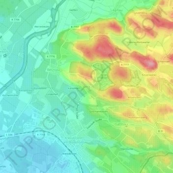
Name: Berg topographic map, elevation, terrain.

Location: Berg, Kressbronn am Bodensee, Verwaltungsverband Eriskirch-Kressbronn am Bodensee-Langenargen, Bodenseekreis, Baden-Württemberg, 88079, Germany (47.58894 9.58478 47.62894 9.62478)

Average elevation: 1,453 ft

Minimum elevation: 1,299 ft

Maximum elevation: 1,739 ft

Other topographic maps

Click on a map to view its topography, its elevation and its terrain.

Lake Constance

Germany > Baden-Württemberg > Bodenseekreis

Average elevation: 1,821 ft

Tettnang

Germany > Baden-Württemberg > Bodenseekreis

Average elevation: 1,499 ft

Tettnang

Germany > Baden-Württemberg > Bodenseekreis

Average elevation: 1,499 ft

Friedrichshafen

Germany > Baden-Württemberg > Bodenseekreis

Friedrichshafen is located on a gently curved bay on the north shore of Lake Constance and on the southwest edge of the Schussen. The city is over an altitude of 395.2 m above sea level. NHH on the shores of Lake Constance up to 501.6 m in Ailingen. The core city is located not far to the west of the…

Average elevation: 1,447 ft

Gear up for your next adventure:

🧭Hiking Compass - Precision compass for reliable navigation in the wilderness
🧭Orienteering Set - Complete compass and map reading kit
🪵Folding Camp Saw - Compact saw for wood and campsite work
🗺️NatGeo Topo Maps - High-quality waterproof printed topographic maps of US Parks
🪑Portable Camp Table - Compact table for campsite meals

As an Amazon Associate, this site earns from qualifying purchases at no extra cost to you.