
Thank you for supporting this site ❤️
Make a donation
Make a donation
Gear up for your next adventure:
As an Amazon Associate, this site earns from qualifying purchases at no extra cost to you.
Oberweidbach topographic map
Click on the map to display elevation.
Thank you for supporting this site ❤️
Make a donation
Make a donation
Gear up for your next adventure:
As an Amazon Associate, this site earns from qualifying purchases at no extra cost to you.
About this map
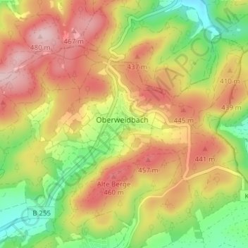
Name: Oberweidbach topographic map, elevation, terrain.
Location: Oberweidbach, Bischoffen, Lahn-Dill-Kreis, Hessen, Deutschland (50.71170 8.48605 50.73964 8.54746)
Average elevation: 1,257 ft
Minimum elevation: 915 ft
Maximum elevation: 1,572 ft
Thank you for supporting this site ❤️
Make a donation
Make a donation
Gear up for your next adventure:
As an Amazon Associate, this site earns from qualifying purchases at no extra cost to you.
Other topographic maps
Click on a map to view its topography, its elevation and its terrain.