Geolocate

Balite topographic map

Click on the map to display elevation.

About this map
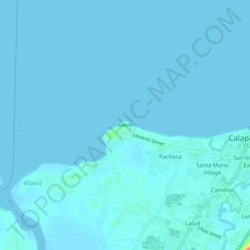
Name: Balite topographic map, elevation, terrain.

Location: Balite, Calapan, Oriental Mindoro, Mimaropa, Philippines (13.39660 121.14010 13.43660 121.18010)

Average elevation: 7 ft

Minimum elevation: 0 ft

Maximum elevation: 171 ft

Other topographic maps

Click on a map to view its topography, its elevation and its terrain.
Masipit

Philippines > Oriental Mindoro > Calapan

Average elevation: 13 ft

Lalud

Philippines > Oriental Mindoro > Calapan

Average elevation: 26 ft

Tibag

Philippines > Oriental Mindoro > Calapan

Average elevation: 16 ft

Santo Niño

Philippines > Oriental Mindoro > Calapan

Average elevation: 62 ft

Camilmil

Philippines > Oriental Mindoro > Calapan

Average elevation: 39 ft

Gear up for your next adventure:

🧣Hiking Neck Gaiter - Multi‑use neck protection for outdoor weather
🌄Hiking Binoculars - Compact binoculars for scenic views and trail spotting
💧Water Purification System - Clean water on the trail with reliable purifiers
🔦Powerful Headlamps - Ultra-bright hands-free lighting for night navigation
🔌USB Car Charger - Car charger for on‑the‑go power needs

As an Amazon Associate, this site earns from qualifying purchases at no extra cost to you.