Geolocate

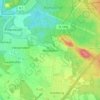
90403 topographic map

Click on the map to display elevation.

About this map

Name: 90403 topographic map, elevation, terrain.

Location: 90403, Altstadt und engere Innenstadt, Nuremberg, Bavaria, Germany (49.44986 11.06904 49.45967 11.08924)

Average elevation: 1,033 ft

Minimum elevation: 968 ft

Maximum elevation: 1,112 ft

Other topographic maps

Click on a map to view its topography, its elevation and its terrain.
Worzeldorf

Germany > Bavaria > Nuremberg

Average elevation: 1,119 ft

Gear up for your next adventure:

🥘Titanium Cookware - Durable, featherlight pots and pans for backpacking
🏔️Mountain Trail Maps - High‑detail maps for popular peaks
🍳Camping Cook Set - Complete cookware for outdoor meals
⛺Backpacking Tents - Weight-optimized shelters for multi-day topographic surveys
🪶Survival Guide Book - Expert advice for emergency preparedness

As an Amazon Associate, this site earns from qualifying purchases at no extra cost to you.