
Make a donation
Gear up for your next adventure:
As an Amazon Associate, this site earns from qualifying purchases at no extra cost to you.
Lutago topographic map
Click on the map to display elevation.
Make a donation
Gear up for your next adventure:
As an Amazon Associate, this site earns from qualifying purchases at no extra cost to you.
Lutago
È situato nella piega di una valle alpina, ad un'altitudine di circa 970 m sopra il livello del mare.
Make a donation
Gear up for your next adventure:
As an Amazon Associate, this site earns from qualifying purchases at no extra cost to you.
About this map
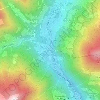
Name: Lutago topographic map, elevation, terrain.
Average elevation: 4,501 ft
Minimum elevation: 3,061 ft
Maximum elevation: 7,231 ft
Make a donation
Gear up for your next adventure:
As an Amazon Associate, this site earns from qualifying purchases at no extra cost to you.
Other topographic maps
Click on a map to view its topography, its elevation and its terrain.
Vedretta di Rio Franco
Italia > Trentino-Alto Adige > Bolzano > Valle Aurina
Average elevation: 8,819 ft