
North Tu Liem District topographic map
Interactive map
Click on the map to display elevation.
About this map
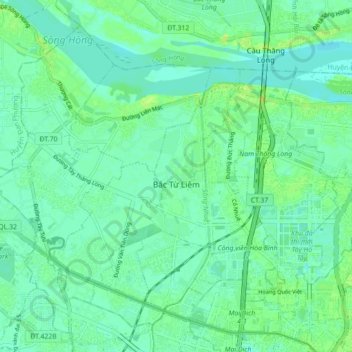
Name: North Tu Liem District topographic map, elevation, terrain.
Location: North Tu Liem District, Hà Nội, 11909, Vietnam (21.03798 105.71732 21.10812 105.80499)
Average elevation: 33 ft
Minimum elevation: 7 ft
Maximum elevation: 89 ft
Other topographic maps
Click on a map to view its topography, its elevation and its terrain.
Phường Minh Khai
Phường Minh Khai, Hai Ba Trung District, Hà Nội, 11617, Vietnam
Average elevation: 39 ft