Geolocate

Milos topographic map

Click on the map to display elevation.

About this map
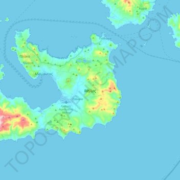
Name: Milos topographic map, elevation, terrain.

Location: Milos, Milos Regional Unit, South Aegean, Aegean, 848 00, Greece (36.64473 24.31725 36.77396 24.54772)

Average elevation: 79 ft

Minimum elevation: -3 ft

Maximum elevation: 1,283 ft

Other topographic maps

Click on a map to view its topography, its elevation and its terrain.

Kalamitsi

Greece > South Aegean > Milos Regional Unit

Average elevation: 89 ft

Kaminia

Greece > South Aegean > Milos Regional Unit > Adamantas

Average elevation: 131 ft

Gear up for your next adventure:

🛡️Insect Repellent - Protection against bugs during outdoor activities
☕Camping Coffee Makers - Enjoy premium coffee at the summit or campsite
🩹Survival Bandages - High‑quality bandages for emergencies
🧣Hiking Neck Gaiter - Multi‑use neck protection for outdoor weather
📡GPS Antenna Upgrade - Enhance GPS reception in remote terrain

As an Amazon Associate, this site earns from qualifying purchases at no extra cost to you.