
Make a donation
Gear up for your next adventure:
As an Amazon Associate, this site earns from qualifying purchases at no extra cost to you.
Newport topographic map
Click on the map to display elevation.
Make a donation
Gear up for your next adventure:
As an Amazon Associate, this site earns from qualifying purchases at no extra cost to you.
Newport
Newport is drained by the west-flowing Sugar River and its South Branch, with the town center at their confluence. The North Branch joins the Sugar River north of Newport village and east of North Newport. The entire town is part of the Connecticut River watershed. The highest point in town is along its southern border, where an unnamed ridge has an elevation of approximately 1,920 feet (590 m) above sea level.
Make a donation
Gear up for your next adventure:
As an Amazon Associate, this site earns from qualifying purchases at no extra cost to you.
About this map
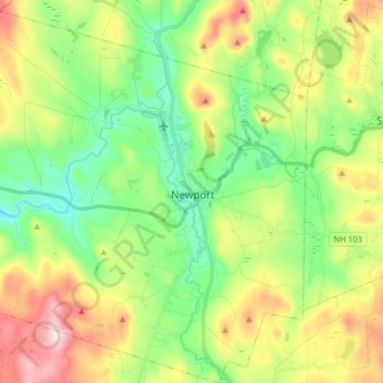
Name: Newport topographic map, elevation, terrain.
Location: Newport, Sullivan County, New Hampshire, United States (43.30758 -72.26954 43.42375 -72.12587)
Average elevation: 1,135 ft
Minimum elevation: 574 ft
Maximum elevation: 1,969 ft
Sullivan County trails, hiking, mountain biking, running and outdoor activities
Make a donation
Gear up for your next adventure:
As an Amazon Associate, this site earns from qualifying purchases at no extra cost to you.
Other topographic maps
Click on a map to view its topography, its elevation and its terrain.
Kolelemook Lake
United States > New Hampshire > Sullivan County > Springfield
Average elevation: 1,519 ft
North Charlestown
United States > New Hampshire > Sullivan County > Charlestown
Average elevation: 531 ft
South Charlestown
United States > New Hampshire > Sullivan County > Charlestown
Average elevation: 502 ft
Make a donation
Gear up for your next adventure:
As an Amazon Associate, this site earns from qualifying purchases at no extra cost to you.
Make a donation
Gear up for your next adventure:
As an Amazon Associate, this site earns from qualifying purchases at no extra cost to you.
East Washington
United States > New Hampshire > Sullivan County > Washington
Average elevation: 1,056 ft