Geolocate

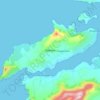
Beaufort topographic map

Click on the map to display elevation.

About this map

Name: Beaufort topographic map, elevation, terrain.

Location: Beaufort, Kenmare Municipal District, County Kerry, Munster, Ireland (52.04897 -9.65665 52.08897 -9.61665)

Average elevation: 135 ft

Minimum elevation: 33 ft

Maximum elevation: 335 ft

Other topographic maps

Click on a map to view its topography, its elevation and its terrain.

Gear up for your next adventure:

🔥Fast-Boil Camping Stoves - Efficient cooking systems for quick trail meals
🗻Climbing Gear Basics - Essential gear for beginner climbers
🪓Survival Multi‑Tool - Versatile tool for camp and trail tasks
🧣Hiking Neck Gaiter - Multi‑use neck protection for outdoor weather
🎒Day Hiking Backpack - Lightweight backpack perfect for day trips and outdoor adventures

As an Amazon Associate, this site earns from qualifying purchases at no extra cost to you.