
Make a donation
Gear up for your next adventure:
As an Amazon Associate, this site earns from qualifying purchases at no extra cost to you.
Schallern topographic map
Click on the map to display elevation.
Make a donation
Gear up for your next adventure:
As an Amazon Associate, this site earns from qualifying purchases at no extra cost to you.
Schallern
Schallern liegt unmittelbar etwa 10 km westlich von Erwitte, 10 km östlich von Soest und 35 km westlich von Paderborn sowie 45 km östlich von Dortmund. Das Dorf liegt zudem auf direkter Höhe des alten Hellwegs bzw. der heutigen Bundesstraße 1.
Make a donation
Gear up for your next adventure:
As an Amazon Associate, this site earns from qualifying purchases at no extra cost to you.
About this map
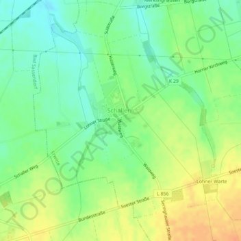
Name: Schallern topographic map, elevation, terrain.
Average elevation: 331 ft
Minimum elevation: 276 ft
Maximum elevation: 394 ft
Make a donation
Gear up for your next adventure:
As an Amazon Associate, this site earns from qualifying purchases at no extra cost to you.
Other topographic maps
Click on a map to view its topography, its elevation and its terrain.
Bad Westernkotten
Deutschland > Nordrhein-Westfalen > Kreis Soest > Erwitte
Wirtschaftlich spielte im 19. Jahrhundert die Salzindustrie weiterhin die wichtigste Rolle und erreichte mit einer jährlichen Produktion von etwa 35.000 Zentnern um 1850 ihren Höhepunkt.
Average elevation: 308 ft