
Make a donation
Gear up for your next adventure:
As an Amazon Associate, this site earns from qualifying purchases at no extra cost to you.
Maynardville City Limits topographic map
Click on the map to display elevation.
Make a donation
Gear up for your next adventure:
As an Amazon Associate, this site earns from qualifying purchases at no extra cost to you.
About this map
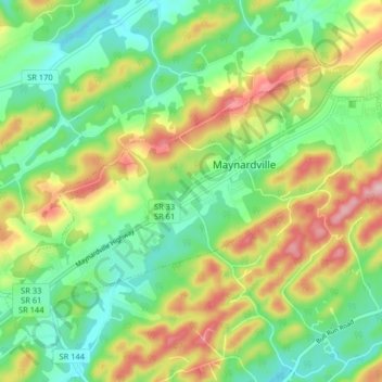
Name: Maynardville City Limits topographic map, elevation, terrain.
Average elevation: 1,322 ft
Minimum elevation: 1,043 ft
Maximum elevation: 1,775 ft
Union County trails, hiking, mountain biking, running and outdoor activities
Make a donation
Gear up for your next adventure:
As an Amazon Associate, this site earns from qualifying purchases at no extra cost to you.
Other topographic maps
Click on a map to view its topography, its elevation and its terrain.
Big Ridge State Park
United States > Tennessee > Union County
Big Ridge State Park is located in the Appalachian Ridge-and-Valley range, which is characterized by narrow elongate ridges flanked by fertile stream valleys. The park's topography is dominated by three such ridge systems running roughly parallel to one another, the two northernmost of which are bisected by…
Average elevation: 1,155 ft
Make a donation
Gear up for your next adventure:
As an Amazon Associate, this site earns from qualifying purchases at no extra cost to you.