
Thank you for supporting this site ❤️
Make a donation
Make a donation
Gear up for your next adventure:
As an Amazon Associate, this site earns from qualifying purchases at no extra cost to you.
Elizondo topographic map
Click on the map to display elevation.
Thank you for supporting this site ❤️
Make a donation
Make a donation
Gear up for your next adventure:
As an Amazon Associate, this site earns from qualifying purchases at no extra cost to you.
About this map
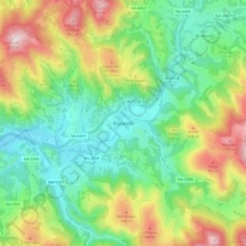
Name: Elizondo topographic map, elevation, terrain.
Location: Elizondo, Baztan, Baztan-Bidasoa, Navarre, 31700, Espagne (43.10633 -1.55838 43.18633 -1.47838)
Average elevation: 1,332 ft
Minimum elevation: 531 ft
Maximum elevation: 2,799 ft
Thank you for supporting this site ❤️
Make a donation
Make a donation
Gear up for your next adventure:
As an Amazon Associate, this site earns from qualifying purchases at no extra cost to you.