Geolocate

Azara topographic map

Click on the map to display elevation.

About this map

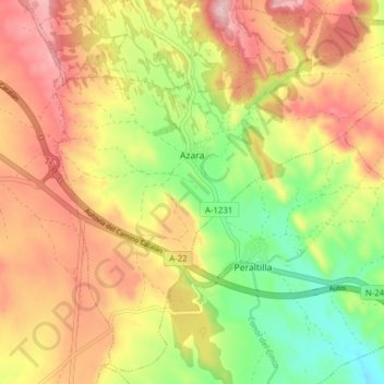
Name: Azara topographic map, elevation, terrain.

Location: Azara, Somontano de Barbastro, Huesca, Aragon, Spain (42.03666 -0.05884 42.09056 0.01884)

Average elevation: 1,562 ft

Minimum elevation: 1,207 ft

Maximum elevation: 1,886 ft

Other topographic maps

Click on a map to view its topography, its elevation and its terrain.

Costean

Spain > Aragon > Somontano de Barbastro > Hoz y Costeán

Average elevation: 1,470 ft

Riana

Spain > Aragon > Somontano de Barbastro > Hoz y Costeán

Average elevation: 1,539 ft

Gear up for your next adventure:

🎒Day Hiking Backpack - Lightweight backpack perfect for day trips and outdoor adventures
📡GPS Antenna Upgrade - Enhance GPS reception in remote terrain
🧥Men's Rain Shells - Premium waterproof and breathable jackets for mountain weather
🚪Portable Camp Chair - Foldable chair for comfort at camp
🦶Hiking Gaiters - Keep debris and water out of your boots

As an Amazon Associate, this site earns from qualifying purchases at no extra cost to you.