Norman topographic map
Interactive map
Click on the map to display elevation.
About this map
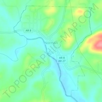
Name: Norman topographic map, elevation, terrain.
Location: Norman, Montgomery County, Arkansas, 71960, United States (34.44248 -93.69358 34.46648 -93.66851)
Average elevation: 745 ft
Minimum elevation: 659 ft
Maximum elevation: 965 ft
Other topographic maps
Click on a map to view its topography, its elevation and its terrain.
Joplin
United States > Arkansas > Montgomery County
Joplin, Montgomery County, Arkansas, United States
Average elevation: 758 ft
Ophir
United States > Arkansas > Montgomery County
Ophir, Montgomery County, Arkansas, United States
Average elevation: 781 ft
Sims
United States > Arkansas > Montgomery County
Sims, Montgomery County, Arkansas, 71969, United States
Average elevation: 745 ft
Mount Ida
United States > Arkansas > Montgomery County
Mount Ida, Montgomery County, Arkansas, United States
Average elevation: 705 ft
Mount Ida
United States > Arkansas > Montgomery County > Mount Ida
Mount Ida, Montgomery County, Arkansas, United States
Average elevation: 705 ft
Mount Ida
United States > Arkansas > Montgomery County > Mount Ida > Mount Ida
Mount Ida, Montgomery County, Arkansas, United States
Average elevation: 709 ft