
Thank you for supporting this site ❤️
Make a donation
Make a donation
Gear up for your next adventure:
As an Amazon Associate, this site earns from qualifying purchases at no extra cost to you.
Caballero topographic map
Click on the map to display elevation.
Thank you for supporting this site ❤️
Make a donation
Make a donation
Gear up for your next adventure:
As an Amazon Associate, this site earns from qualifying purchases at no extra cost to you.
About this map
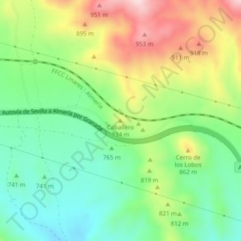
Name: Caballero topographic map, elevation, terrain.
Location: Caballero, Nacimiento, Almería, Andalucía, España (37.13753 -2.65853 37.13763 -2.65843)
Average elevation: 2,575 ft
Minimum elevation: 2,178 ft
Maximum elevation: 3,199 ft
Thank you for supporting this site ❤️
Make a donation
Make a donation
Gear up for your next adventure:
As an Amazon Associate, this site earns from qualifying purchases at no extra cost to you.