Geolocate

Waverly Way topographic map

Click on the map to display elevation.

About this map

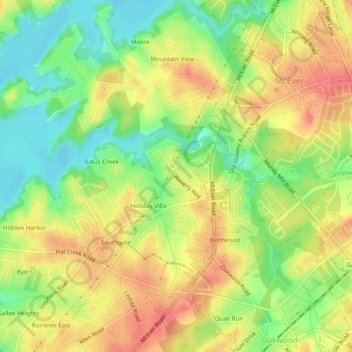
Name: Waverly Way topographic map, elevation, terrain.

Location: Waverly Way, Hall County, Georgia, 30566, United States (34.22621 -83.91851 34.26621 -83.87851)

Average elevation: 1,168 ft

Minimum elevation: 1,053 ft

Maximum elevation: 1,273 ft

Hall County trails, hiking, mountain biking, running and outdoor activities

Other topographic maps

Click on a map to view its topography, its elevation and its terrain.

Clermont

United States > Georgia > Hall County

Average elevation: 1,394 ft

Flowery Branch

United States > Georgia > Hall County

Average elevation: 1,125 ft

Don Carter State Park

United States > Georgia > Hall County

Average elevation: 1,161 ft

Gear up for your next adventure:

🔦Powerful Headlamps - Ultra-bright hands-free lighting for night navigation
🩳Quick‑Dry Hiking Shorts - Comfortable and quick‑dry shorts for summer hiking
🚪Portable Camp Chair - Foldable chair for comfort at camp
🗺️Topographic Maps - Detailed topo maps for hiking, exploring and outdoor navigation
📚USA Hiking Guide Books - Top trail guides and map books

As an Amazon Associate, this site earns from qualifying purchases at no extra cost to you.