Geolocate

Rhos topographic map

Click on the map to display elevation.

About this map

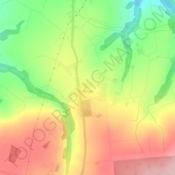
Name: Rhos topographic map, elevation, terrain.

Location: Rhos, Llangeler, Carmarthenshire, Wales, United Kingdom (51.98973 -4.36719 51.99895 -4.35123)

Average elevation: 676 ft

Minimum elevation: 318 ft

Maximum elevation: 1,014 ft

Gear up for your next adventure:

👖Convertible Hiking Pants - Versatile zip-off pants for changing altitudes and temperatures
🔥Fast-Boil Camping Stoves - Efficient cooking systems for quick trail meals
📶Satellite Messenger - Communication device off‑grid
🦶Hiking Gaiters - Keep debris and water out of your boots
🌡️Portable Weather Meter - Track weather conditions on the trail

As an Amazon Associate, this site earns from qualifying purchases at no extra cost to you.