Geolocate

Chedgrave topographic map

Click on the map to display elevation.

About this map

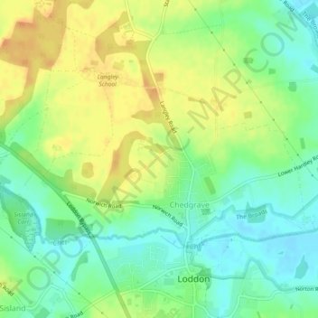
Name: Chedgrave topographic map, elevation, terrain.

Location: Chedgrave, South Norfolk, Norfolk, England, United Kingdom (52.53769 1.45406 52.55290 1.49906)

Average elevation: 52 ft

Minimum elevation: 0 ft

Maximum elevation: 112 ft

Gear up for your next adventure:

🧷Carabiner Set - Durable clips for gear attachment
🧭Map Reading Tools - Tools and kits for map navigation
☀️Outdoor Sunscreen - High protection sunscreen for outdoor activities
🧤Tactile Hiking Gloves - Keep hands warm while operating GPS and smartphone screens
🪑Portable Camp Table - Compact table for campsite meals

As an Amazon Associate, this site earns from qualifying purchases at no extra cost to you.