
Make a donation
Gear up for your next adventure:
As an Amazon Associate, this site earns from qualifying purchases at no extra cost to you.
Pine Island topographic map
Click on the map to display elevation.
Make a donation
Gear up for your next adventure:
As an Amazon Associate, this site earns from qualifying purchases at no extra cost to you.
About this map
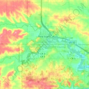
Name: Pine Island topographic map, elevation, terrain.
Location: Pine Island, Goodhue County, Minnesota, United States (44.17309 -92.67138 44.21720 -92.54342)
Average elevation: 1,073 ft
Minimum elevation: 955 ft
Maximum elevation: 1,237 ft
Goodhue County trails, hiking, mountain biking, running and outdoor activities
Make a donation
Gear up for your next adventure:
As an Amazon Associate, this site earns from qualifying purchases at no extra cost to you.
Other topographic maps
Click on a map to view its topography, its elevation and its terrain.
Cannon Falls
United States > Minnesota > Goodhue County > Cannon Falls > Cannon Falls
Average elevation: 879 ft
Make a donation
Gear up for your next adventure:
As an Amazon Associate, this site earns from qualifying purchases at no extra cost to you.