
Thank you for supporting this site ❤️
Make a donation
Make a donation
Gear up for your next adventure:
As an Amazon Associate, this site earns from qualifying purchases at no extra cost to you.
Dungu topographic map
Click on the map to display elevation.
Thank you for supporting this site ❤️
Make a donation
Make a donation
Gear up for your next adventure:
As an Amazon Associate, this site earns from qualifying purchases at no extra cost to you.
About this map
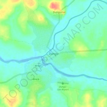
Name: Dungu topographic map, elevation, terrain.
Location: Dungu, Upper Uele, Democratic Republic of the Congo (3.57954 28.52992 3.65954 28.60992)
Average elevation: 2,293 ft
Minimum elevation: 2,244 ft
Maximum elevation: 2,431 ft
Thank you for supporting this site ❤️
Make a donation
Make a donation
Gear up for your next adventure:
As an Amazon Associate, this site earns from qualifying purchases at no extra cost to you.