
Batesville topographic map
Click on the map to display elevation.
About this map
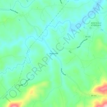
Name: Batesville topographic map, elevation, terrain.
Location: Batesville, Albemarle County, Virginia, 22924, United States (37.97570 -78.74224 38.01570 -78.70224)
Average elevation: 722 ft
Minimum elevation: 528 ft
Maximum elevation: 1,322 ft
Albemarle County trails, hiking, mountain biking, running and outdoor activities
Other topographic maps
Click on a map to view its topography, its elevation and its terrain.
Beaver Creek Park
United States > Virginia > Albemarle County > Charlottesville > Wickham Pond
Average elevation: 607 ft
Darden Towe Park
United States > Virginia > Albemarle County > Charlottesville > Franklin
Average elevation: 423 ft