
Make a donation
Gear up for your next adventure:
As an Amazon Associate, this site earns from qualifying purchases at no extra cost to you.
Cafayate topographic map
Click on the map to display elevation.
Make a donation
Gear up for your next adventure:
As an Amazon Associate, this site earns from qualifying purchases at no extra cost to you.
About this map
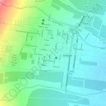
Name: Cafayate topographic map, elevation, terrain.
Location: Cafayate, Salta, A4427AHB, Argentina (-26.08157 -65.99809 -26.06313 -65.97075)
Average elevation: 5,331 ft
Minimum elevation: 5,249 ft
Maximum elevation: 5,531 ft
Make a donation
Gear up for your next adventure:
As an Amazon Associate, this site earns from qualifying purchases at no extra cost to you.
Other topographic maps
Click on a map to view its topography, its elevation and its terrain.
Colomé
Colomé is a village and rural municipality in Salta Province in northwestern Argentina. It is located about 20 km from Molinos, Salta. This settlement was established by the last Spanish governor of Salta, Nicolás Severo de Isasmendi, in 1831. His daughter Ascención imported grapevines from France and…
Average elevation: 7,520 ft
Make a donation
Gear up for your next adventure:
As an Amazon Associate, this site earns from qualifying purchases at no extra cost to you.
Make a donation
Gear up for your next adventure:
As an Amazon Associate, this site earns from qualifying purchases at no extra cost to you.
Nevado de Quehuar
Argentina > Salta > Municipio de San Antonio de los Cobres
Average elevation: 18,822 ft