Geolocate

Lajas topographic map

Click on the map to display elevation.

About this map

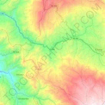
Name: Lajas topographic map, elevation, terrain.

Location: Lajas, Province of Chota, Cajamarca, Peru (-6.66141 -78.78667 -6.47228 -78.67121)

Average elevation: 8,491 ft

Minimum elevation: 5,574 ft

Maximum elevation: 12,316 ft

Gear up for your next adventure:

🍳Camping Cook Set - Complete cookware for outdoor meals
🪑Ultralight Camp Chairs - Portable seating for resting after a long day of mapping
🕶️GPS Smartphone Mount - Secure mount for phone navigation
🦟Ultrasonic Repellers - Create a bug-free zone at your camp or rest stop
📡Handheld GPS Device - Reliable handheld GPS for outdoor navigation

As an Amazon Associate, this site earns from qualifying purchases at no extra cost to you.