
Make a donation
Gear up for your next adventure:
As an Amazon Associate, this site earns from qualifying purchases at no extra cost to you.
Vilariño topographic map
Click on the map to display elevation.
Make a donation
Gear up for your next adventure:
As an Amazon Associate, this site earns from qualifying purchases at no extra cost to you.
About this map
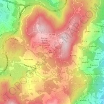
Name: Vilariño topographic map, elevation, terrain.
Location: Vilariño, Zamáns, Vigo, Pontevedra, Galicia, 36310, España (42.14572 -8.69944 42.18572 -8.65944)
Average elevation: 1,132 ft
Minimum elevation: 358 ft
Maximum elevation: 1,673 ft
Make a donation
Gear up for your next adventure:
As an Amazon Associate, this site earns from qualifying purchases at no extra cost to you.
Other topographic maps
Click on a map to view its topography, its elevation and its terrain.
Make a donation
Gear up for your next adventure:
As an Amazon Associate, this site earns from qualifying purchases at no extra cost to you.
Parque Nacional Marítimo Terrestre de las Islas Atlánticas de Galicia
España > Galicia > Vigo > Vigo
Average elevation: 154 ft
Make a donation
Gear up for your next adventure:
As an Amazon Associate, this site earns from qualifying purchases at no extra cost to you.