
信丰县 topographic map
Interactive map
Click on the map to display elevation.
About this map
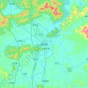
Name: 信丰县 topographic map, elevation, terrain.
Location: 信丰县, 赣州市, 江西省, 中国 (25.22887 114.75833 25.54887 115.07833)
Average elevation: 709 ft
Minimum elevation: 430 ft
Maximum elevation: 2,438 ft
Other topographic maps
Click on a map to view its topography, its elevation and its terrain.