Geolocate

Scala topographic map

Click on the map to display elevation.

About this map

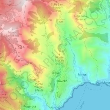
Name: Scala topographic map, elevation, terrain.

Location: Scala, Salerno, Campania, 84010, Italy (40.63577 14.55518 40.68811 14.61181)

Average elevation: 1,611 ft

Minimum elevation: -13 ft

Maximum elevation: 4,055 ft

Other topographic maps

Click on a map to view its topography, its elevation and its terrain.

Montepertuso

Italy > Campania > Salerno > Arienzo

Average elevation: 1,493 ft

Valico di Chiunzi

Italy > Campania > Salerno

Average elevation: 1,680 ft

Persano

Italy > Campania > Salerno > Serre

Average elevation: 82 ft

Sicilì

Italy > Campania > Salerno

Average elevation: 748 ft

Il Gallo Lungo

Italy > Campania > Salerno > Positano

Average elevation: 0 ft

M.Licosa

Italy > Campania > Salerno

Average elevation: 374 ft

Gear up for your next adventure:

🧭Map Reading Tools - Tools and kits for map navigation
🔌Solar Panel Charger - Charge gear sustainably outdoors
🍳Camping Cook Set - Complete cookware for outdoor meals
🎒Gear Packing Cubes - Organize your backpack efficiently
🧢Sun Protection Hats - Wide-brimmed and UPF-rated hats for high-altitude sun safety

As an Amazon Associate, this site earns from qualifying purchases at no extra cost to you.