Geolocate

Wittem topographic map

Click on the map to display elevation.

About this map

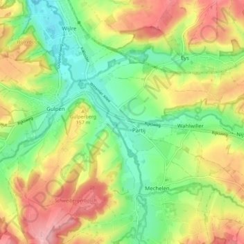
Name: Wittem topographic map, elevation, terrain.

Location: Wittem, Gulpen-Wittem, Limburg, Netherlands (50.79802 5.89814 50.82406 5.98352)

Average elevation: 453 ft

Minimum elevation: 259 ft

Maximum elevation: 696 ft

Other topographic maps

Click on a map to view its topography, its elevation and its terrain.

Heierhoeven

Netherlands > Limburg > Venlo

Average elevation: 89 ft

Mariapeel

Netherlands > Limburg > Evertsoord

Average elevation: 105 ft

Cottessen

Netherlands > Limburg > Vijlen

Average elevation: 600 ft

Overheek

Netherlands > Limburg > Termaar

Average elevation: 387 ft

Maastricht

Netherlands > Limburg > Maastricht

Average elevation: 331 ft

Horick

Netherlands > Limburg > Ospel > Horick

Average elevation: 105 ft

Schimmert

Netherlands > Limburg > Schimmert > Schimmert

Average elevation: 410 ft

Hout-Blerick

Netherlands > Limburg > Venlo

Average elevation: 72 ft

Gear up for your next adventure:

🖼️Topo Map Wall Art - Decorative topographic prints of famous peaks and regions
👓Polarized Sunglasses - Outdoor sunglasses for glare reduction
🦟Ultrasonic Repellers - Create a bug-free zone at your camp or rest stop
🗺️Topographic Maps - Detailed topo maps for hiking, exploring and outdoor navigation
📖Nature Tracking Books - Learn to track wildlife and terrain

As an Amazon Associate, this site earns from qualifying purchases at no extra cost to you.