
Make a donation
Gear up for your next adventure:
As an Amazon Associate, this site earns from qualifying purchases at no extra cost to you.
Vail Pass topographic map
Click on the map to display elevation.
Make a donation
Gear up for your next adventure:
As an Amazon Associate, this site earns from qualifying purchases at no extra cost to you.
About this map
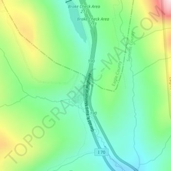
Name: Vail Pass topographic map, elevation, terrain.
Location: Vail Pass, Summit County, Colorado, États-Unis d'Amérique (39.52940 -106.21685 39.52950 -106.21675)
Average elevation: 10,804 ft
Minimum elevation: 10,299 ft
Maximum elevation: 11,854 ft
Make a donation
Gear up for your next adventure:
As an Amazon Associate, this site earns from qualifying purchases at no extra cost to you.
Other topographic maps
Click on a map to view its topography, its elevation and its terrain.
Camp Hale - Continental Divide National Monument
États-Unis d'Amérique > Colorado > Summit County > Breckenridge
Average elevation: 10,997 ft
Make a donation
Gear up for your next adventure:
As an Amazon Associate, this site earns from qualifying purchases at no extra cost to you.