Geolocate

Whipple topographic map

Click on the map to display elevation.

About this map

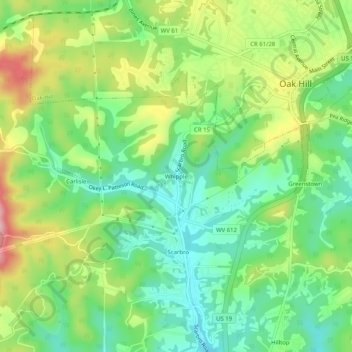
Name: Whipple topographic map, elevation, terrain.

Location: Whipple, Fayette County, West Virginia, 25917, United States (37.94178 -81.18594 37.98178 -81.14594)

Average elevation: 1,896 ft

Minimum elevation: 1,660 ft

Maximum elevation: 2,287 ft

Other topographic maps

Click on a map to view its topography, its elevation and its terrain.

Thurmond

United States > West Virginia > Fayette County

Average elevation: 1,542 ft

Meadow Bridge

United States > West Virginia > Fayette County

Average elevation: 2,546 ft

Gauley Bridge

United States > West Virginia > Fayette County

Average elevation: 1,079 ft

Fayetteville

United States > West Virginia > Fayette County

Average elevation: 1,670 ft

Prince

United States > West Virginia > Fayette County

Average elevation: 1,736 ft

Oak Hill

United States > West Virginia > Fayette County

Average elevation: 1,903 ft

Hico

United States > West Virginia > Fayette County

Average elevation: 2,037 ft

Fayetteville

United States > West Virginia > Fayette County

Average elevation: 1,670 ft

Thurmond

United States > West Virginia > Fayette County

Average elevation: 1,545 ft

Gear up for your next adventure:

🦟Ultrasonic Repellers - Create a bug-free zone at your camp or rest stop
🔭Stargazing Telescopes - Perfect for camping in low-light pollution areas shown on maps
🔌Solar Panel Charger - Charge gear sustainably outdoors
🏕️Tent Footprint - Protect your tent base from wear
Backpacking Tents - Weight-optimized shelters for multi-day topographic surveys

As an Amazon Associate, this site earns from qualifying purchases at no extra cost to you.