Make a donation
Gear up for your next adventure:
As an Amazon Associate, this site earns from qualifying purchases at no extra cost to you.
Dallas topographic map
Click on the map to display elevation.
Make a donation
Gear up for your next adventure:
As an Amazon Associate, this site earns from qualifying purchases at no extra cost to you.
About this map
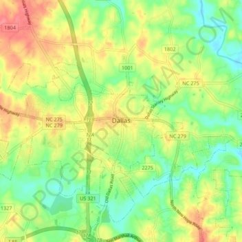
Name: Dallas topographic map, elevation, terrain.
Location: Dallas, Gaston County, North Carolina, United States (35.29938 -81.21529 35.33231 -81.13238)
Average elevation: 748 ft
Minimum elevation: 646 ft
Maximum elevation: 869 ft
Gaston County trails, hiking, mountain biking, running and outdoor activities
Make a donation
Gear up for your next adventure:
As an Amazon Associate, this site earns from qualifying purchases at no extra cost to you.
Other topographic maps
Click on a map to view its topography, its elevation and its terrain.
Make a donation
Gear up for your next adventure:
As an Amazon Associate, this site earns from qualifying purchases at no extra cost to you.
Make a donation
Gear up for your next adventure:
As an Amazon Associate, this site earns from qualifying purchases at no extra cost to you.
Carolina Industrial Park
United States > North Carolina > Gaston County > Cherryville
Average elevation: 909 ft
Gastonia
United States > North Carolina > Gaston County > Gastonia > Gastonia
Average elevation: 768 ft
Make a donation
Gear up for your next adventure:
As an Amazon Associate, this site earns from qualifying purchases at no extra cost to you.
Make a donation
Gear up for your next adventure:
As an Amazon Associate, this site earns from qualifying purchases at no extra cost to you.
