
Make a donation
Gear up for your next adventure:
As an Amazon Associate, this site earns from qualifying purchases at no extra cost to you.
Adelsberg topographic map
Click on the map to display elevation.
Make a donation
Gear up for your next adventure:
As an Amazon Associate, this site earns from qualifying purchases at no extra cost to you.
About this map
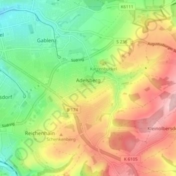
Name: Adelsberg topographic map, elevation, terrain.
Location: Adelsberg, Chemnitz, Lichtenau, Sachsen, Deutschland (50.78984 12.96081 50.83417 13.02360)
Average elevation: 1,302 ft
Minimum elevation: 1,014 ft
Maximum elevation: 1,644 ft
Make a donation
Gear up for your next adventure:
As an Amazon Associate, this site earns from qualifying purchases at no extra cost to you.
Other topographic maps
Click on a map to view its topography, its elevation and its terrain.
Chemnitz
Deutschland > Sachsen > Chemnitz
Chemnitz bildet mit den beiden anderen sächsischen Großstädten Leipzig und Dresden ein Städtedreieck, wobei Chemnitz den südwestlichen Eckpunkt bildet. Die Stadt liegt im Erzgebirgsbecken, umrahmt von Ausläufern des Erzgebirges im Süden und von Höhen des Mittelsächsischen Berglandes im Norden auf etwa…
Average elevation: 1,243 ft
Make a donation
Gear up for your next adventure:
As an Amazon Associate, this site earns from qualifying purchases at no extra cost to you.
Berbisdorf
Deutschland > Sachsen > Chemnitz
Berbisdorf liegt im Süden der Stadt Chemnitz auf ca. 380–480 m ü. NN im Berbisdorfer Riedelgebiet. Nördlich befindet sich der Chemnitzer Stadtteil Harthau, östlich Einsiedel (zu welchem Berbisdorf verwaltungstechnisch gehört) und westlich Klaffenbach. Im Süden grenzt Berbisdorf an den Erzgebirgskreis.…
Average elevation: 1,427 ft
Make a donation
Gear up for your next adventure:
As an Amazon Associate, this site earns from qualifying purchases at no extra cost to you.