
Make a donation
Gear up for your next adventure:
As an Amazon Associate, this site earns from qualifying purchases at no extra cost to you.
Cardoze topographic map
Click on the map to display elevation.
Make a donation
Gear up for your next adventure:
As an Amazon Associate, this site earns from qualifying purchases at no extra cost to you.
About this map
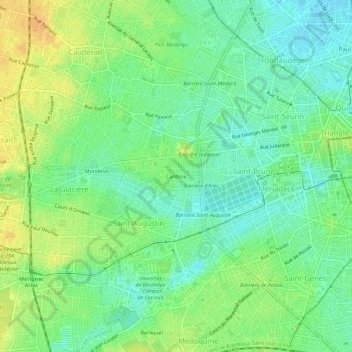
Name: Cardoze topographic map, elevation, terrain.
Average elevation: 66 ft
Minimum elevation: 20 ft
Maximum elevation: 121 ft
Make a donation
Gear up for your next adventure:
As an Amazon Associate, this site earns from qualifying purchases at no extra cost to you.
Other topographic maps
Click on a map to view its topography, its elevation and its terrain.
Bordeaux Maritime
France > Nouvelle-Aquitaine > Gironde > Bordeaux
Le canton de Bordeaux-1 est organisé dans l'arrondissement de Bordeaux, dans la partie nord de la commune de Bordeaux. Son altitude varie de 1 m à 42 m pour une altitude moyenne de 6 m.
Average elevation: 36 ft
Make a donation
Gear up for your next adventure:
As an Amazon Associate, this site earns from qualifying purchases at no extra cost to you.
Make a donation
Gear up for your next adventure:
As an Amazon Associate, this site earns from qualifying purchases at no extra cost to you.