Geolocate

Chartierville topographic map

Click on the map to display elevation.

About this map
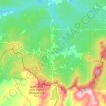
Name: Chartierville topographic map, elevation, terrain.

Location: Chartierville, Le Haut-Saint-François, Estrie, Quebec, J0B 1K0, Canada (45.23944 -71.34035 45.35178 -71.13092)

Average elevation: 1,939 ft

Minimum elevation: 1,263 ft

Maximum elevation: 3,340 ft

Other topographic maps

Click on a map to view its topography, its elevation and its terrain.
Mont Mégantic

Canada > Quebec > Le Haut-Saint-François > La Patrie

Average elevation: 2,927 ft

Island Brook

Canada > Quebec > Le Haut-Saint-François > Newport

Average elevation: 1,115 ft

Le Pain de Sucre

Canada > Quebec > Le Haut-Saint-François > Hampden

Average elevation: 1,696 ft

Island Brook

Canada > Quebec > Le Haut-Saint-François > Newport

Average elevation: 1,115 ft

Maple Leaf

Canada > Quebec > Le Haut-Saint-François > Newport

Average elevation: 1,243 ft

Gould

Canada > Quebec > Le Haut-Saint-François > Lingwick

Average elevation: 1,056 ft

Gear up for your next adventure:

🔦Powerful Headlamps - Ultra-bright hands-free lighting for night navigation
🪶Multi‑Purpose Knife - Useful blade for camp and trail
⌚GPS Sports Watch - GPS watch for running, hiking and training
🗃️Trail First Aid Kit - Essential kit for outdoor injuries and emergencies
🏥Hiking First Aid Kits - Comprehensive medical kits for remote trail injuries

As an Amazon Associate, this site earns from qualifying purchases at no extra cost to you.