
Make a donation
Gear up for your next adventure:
As an Amazon Associate, this site earns from qualifying purchases at no extra cost to you.
Bottenberg topographic map
Click on the map to display elevation.
Make a donation
Gear up for your next adventure:
As an Amazon Associate, this site earns from qualifying purchases at no extra cost to you.
About this map
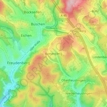
Name: Bottenberg topographic map, elevation, terrain.
Average elevation: 1,155 ft
Minimum elevation: 873 ft
Maximum elevation: 1,526 ft
Make a donation
Gear up for your next adventure:
As an Amazon Associate, this site earns from qualifying purchases at no extra cost to you.
Other topographic maps
Click on a map to view its topography, its elevation and its terrain.
Niederndorf
Deutschland > Nordrhein-Westfalen > Kreis Siegen-Wittgenstein > Freudenberg
Average elevation: 1,030 ft
Büschergrund
Deutschland > Nordrhein-Westfalen > Kreis Siegen-Wittgenstein > Freudenberg
Büschergrund liegt im oberen Talende der Weibe auf einer Höhe zwischen 290 und 360 m ü. NN.
Average elevation: 1,230 ft
Oberfischbach
Deutschland > Nordrhein-Westfalen > Kreis Siegen-Wittgenstein > Freudenberg
Average elevation: 1,060 ft