
Make a donation
Gear up for your next adventure:
As an Amazon Associate, this site earns from qualifying purchases at no extra cost to you.
Mediona topographic map
Click on the map to display elevation.
Make a donation
Gear up for your next adventure:
As an Amazon Associate, this site earns from qualifying purchases at no extra cost to you.
About this map
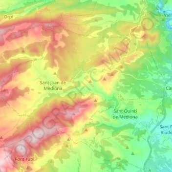
Name: Mediona topographic map, elevation, terrain.
Location: Mediona, Alt Penedès, Barcelona, Catalonia, 08773, Spain (41.44375 1.57032 41.51328 1.70238)
Average elevation: 1,542 ft
Minimum elevation: 725 ft
Maximum elevation: 2,579 ft
Make a donation
Gear up for your next adventure:
As an Amazon Associate, this site earns from qualifying purchases at no extra cost to you.
Other topographic maps
Click on a map to view its topography, its elevation and its terrain.
les Casetes del Pujol
Spain > Catalonia > Alt Penedès > Castellví de la Marca > la Múnia
Average elevation: 607 ft
Make a donation
Gear up for your next adventure:
As an Amazon Associate, this site earns from qualifying purchases at no extra cost to you.