Geolocate

Ciputat Timur topographic map

Click on the map to display elevation.

About this map

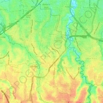
Name: Ciputat Timur topographic map, elevation, terrain.

Location: Ciputat Timur, South Tangerang, Banten, Java, Indonesia (-6.32629 106.72582 -6.26952 106.78001)

Average elevation: 138 ft

Minimum elevation: 56 ft

Maximum elevation: 197 ft

Other topographic maps

Click on a map to view its topography, its elevation and its terrain.

Sutera Olivia

Indonesia > Banten > South Tangerang

Average elevation: 82 ft

Cadasmampar

Indonesia > Banten > South Tangerang > Serpong

Average elevation: 138 ft

Virginia Lagoon

Indonesia > Banten > South Tangerang

Average elevation: 112 ft

Baruasih

Indonesia > Banten > South Tangerang

Average elevation: 154 ft

Cadasmampar

Indonesia > Banten > South Tangerang

Average elevation: 138 ft

Cadasmampar

Indonesia > Banten > South Tangerang

Average elevation: 138 ft

Caribbean Islands

Indonesia > Banten > South Tangerang

Average elevation: 157 ft

Cadasmampar

Indonesia > Banten > South Tangerang

Average elevation: 138 ft

Pamulang

Indonesia > Banten > South Tangerang

Average elevation: 200 ft

BSD

Indonesia > Banten > South Tangerang

Average elevation: 108 ft

BSD

Indonesia > Banten > South Tangerang

Average elevation: 108 ft

De Latinos

Indonesia > Banten > South Tangerang

Average elevation: 151 ft

BSD

Indonesia > Banten > South Tangerang

Average elevation: 108 ft

Pamulang

Indonesia > Banten > South Tangerang

Average elevation: 200 ft

Gear up for your next adventure:

🎒Waterproof Dry Bags - Keep your electronics and maps dry inside your pack
Camping Coffee Makers - Enjoy premium coffee at the summit or campsite
🔭Telescopic Hiking Pole - Adjustable pole for hiking stability
🔦Powerful Headlamps - Ultra-bright hands-free lighting for night navigation
📱Heavy-Duty Phone Cases - Drop-proof and waterproof protection for outdoor navigation

As an Amazon Associate, this site earns from qualifying purchases at no extra cost to you.