
Thank you for supporting this site ❤️
Make a donation
Make a donation
Gear up for your next adventure:
As an Amazon Associate, this site earns from qualifying purchases at no extra cost to you.
Cabroelo topographic map
Click on the map to display elevation.
Thank you for supporting this site ❤️
Make a donation
Make a donation
Gear up for your next adventure:
As an Amazon Associate, this site earns from qualifying purchases at no extra cost to you.
About this map
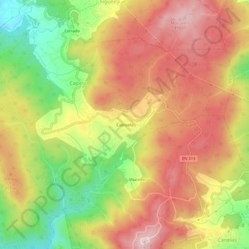
Name: Cabroelo topographic map, elevation, terrain.
Location: Cabroelo, Capela, Penafiel, Porto, 4560-192, Portugal (41.07605 -8.35835 41.11605 -8.31835)
Average elevation: 1,138 ft
Minimum elevation: 525 ft
Maximum elevation: 1,624 ft
Thank you for supporting this site ❤️
Make a donation
Make a donation
Gear up for your next adventure:
As an Amazon Associate, this site earns from qualifying purchases at no extra cost to you.