
Make a donation
Gear up for your next adventure:
As an Amazon Associate, this site earns from qualifying purchases at no extra cost to you.
Perry City topographic map
Click on the map to display elevation.
Make a donation
Gear up for your next adventure:
As an Amazon Associate, this site earns from qualifying purchases at no extra cost to you.
About this map
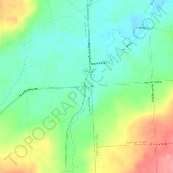
Name: Perry City topographic map, elevation, terrain.
Location: Perry City, Schuyler County, New York, 14886, United States (42.47202 -76.71467 42.51202 -76.67467)
Average elevation: 1,083 ft
Minimum elevation: 958 ft
Maximum elevation: 1,309 ft
Schuyler County trails, hiking, mountain biking, running and outdoor activities
Make a donation
Gear up for your next adventure:
As an Amazon Associate, this site earns from qualifying purchases at no extra cost to you.
Other topographic maps
Click on a map to view its topography, its elevation and its terrain.
Lamoka Lake
United States > New York > Schuyler County > Town of Tyrone > Weston
Average elevation: 1,152 ft
Make a donation
Gear up for your next adventure:
As an Amazon Associate, this site earns from qualifying purchases at no extra cost to you.
Burdett
United States > New York > Schuyler County > Burdett > Town of Hector
Average elevation: 932 ft