
Tonalá topographic map
Interactive map
Click on the map to display elevation.
About this map
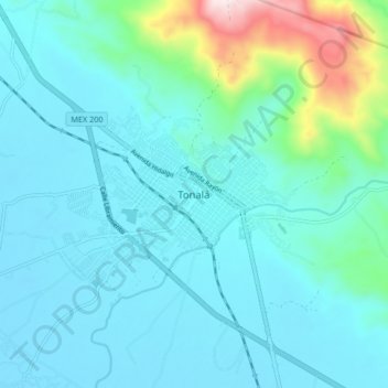
Name: Tonalá topographic map, elevation, terrain.
Location: Tonalá, Chiapas, 30500, México (16.04945 -93.79465 16.12945 -93.71465)
Average elevation: 394 ft
Minimum elevation: 66 ft
Maximum elevation: 2,264 ft
Other topographic maps
Click on a map to view its topography, its elevation and its terrain.
Tres Picos
Tres Picos, Tonalá, Chiapas, 30515, México
Average elevation: 141 ft
Puerto Arista
México > Chiapas > Tonalá > Puerto Arista
Puerto Arista, Tonalá, Chiapas, México
Average elevation: 7 ft
Boca del Cielo
México > Chiapas > Tonalá > Boca del Cielo
Boca del Cielo, Tonalá, Chiapas, México
Average elevation: 10 ft