
Thank you for supporting this site ❤️
Make a donation
Make a donation
Gear up for your next adventure:
As an Amazon Associate, this site earns from qualifying purchases at no extra cost to you.
Pointe-Noire topographic map
Click on the map to display elevation.
Thank you for supporting this site ❤️
Make a donation
Make a donation
Gear up for your next adventure:
As an Amazon Associate, this site earns from qualifying purchases at no extra cost to you.
About this map
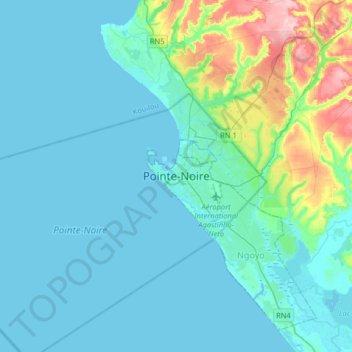
Name: Pointe-Noire topographic map, elevation, terrain.
Location: Pointe-Noire, Hinda, Lumumba, Pointe-Noire, Congo-Brazzaville (-4.95754 11.69033 -4.63754 12.01033)
Average elevation: 89 ft
Minimum elevation: -7 ft
Maximum elevation: 623 ft
Thank you for supporting this site ❤️
Make a donation
Make a donation
Gear up for your next adventure:
As an Amazon Associate, this site earns from qualifying purchases at no extra cost to you.