Geolocate

Le Freney topographic map

Click on the map to display elevation.

About this map
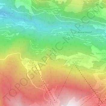
Name: Le Freney topographic map, elevation, terrain.

Location: Le Freney, Saint-Bon-Tarentaise, Courchevel, Albertville, Savoie, Auvergne-Rhône-Alpes, France métropolitaine, 73120, France (45.41510 6.58848 45.45510 6.62848)

Average elevation: 4,193 ft

Minimum elevation: 2,011 ft

Maximum elevation: 6,818 ft

Other topographic maps

Click on a map to view its topography, its elevation and its terrain.

Saint-Bon-Tarentaise

France > Auvergne-Rhône-Alpes > Savoie > Courchevel

La commune de Saint-Bon-Tarentaise se situe dans le massif de la Vanoise dans les Alpes. Elle est à ce titre une commune de montagne dont l'altitude minimale s'établit à 700 mètres et dont le point culminant est le sommet de l'aiguille du Fruit à 3 051 m.

Average elevation: 6,365 ft

Gear up for your next adventure:

🧥Men's Rain Shells - Premium waterproof and breathable jackets for mountain weather
🏔️Mountain Trail Maps - High‑detail maps for popular peaks
🛰️Handheld GPS Units - Professional satellite navigators for precise backcountry mapping
🛶Inflatable Kayak - Portable kayak for rivers, lakes, and expeditions
🪄Magnetic Compass - Accurate compass for navigation

As an Amazon Associate, this site earns from qualifying purchases at no extra cost to you.