
Make a donation
Gear up for your next adventure:
As an Amazon Associate, this site earns from qualifying purchases at no extra cost to you.
Wildenthal topographic map
Click on the map to display elevation.
Make a donation
Gear up for your next adventure:
As an Amazon Associate, this site earns from qualifying purchases at no extra cost to you.
Wildenthal
Der staatlich anerkannte Erholungsort liegt im tiefeingekerbten Tal der Großen Bockau am Fuße des 1019 m hohen Auersberges im Naturpark Erzgebirge/Vogtland. Der Ort liegt auf Höhen zwischen 720 und 1019 m ü. NN. Zu Wildenthal gehört auch der an der Staatsstraße nach Johanngeorgenstadt gelegene Ortsteil Oberwildenthal. Im Ort zweigt eine Verbindungsstraße nach Carlsfeld ab.
Make a donation
Gear up for your next adventure:
As an Amazon Associate, this site earns from qualifying purchases at no extra cost to you.
About this map
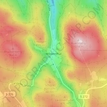
Name: Wildenthal topographic map, elevation, terrain.
Average elevation: 2,805 ft
Minimum elevation: 2,195 ft
Maximum elevation: 3,330 ft
Make a donation
Gear up for your next adventure:
As an Amazon Associate, this site earns from qualifying purchases at no extra cost to you.
Other topographic maps
Click on a map to view its topography, its elevation and its terrain.
Eibenstock
Deutschland > Sachsen > Erzgebirgskreis > Eibenstock
Aufgrund der Höhenlage von mehr als 600 m wird Eibenstock nicht zu den allerersten Bauerndörfern im Erzgebirge gehört haben. Es gibt die Einschätzung, es sei als dauerhafte Ansiedlung in Form eines Radialwaldhufendorfes frühestens im Laufe des 13. Jahrhunderts im Bereich der späteren Herrschaft…
Average elevation: 2,464 ft
Sosa
Deutschland > Sachsen > Erzgebirgskreis > Eibenstock
Sosa liegt im Westerzgebirge. Nach der Naturraumkarte von Sachsen gehört es zur Mesogeochore „Bockauer Hochfläche“ und innerhalb dieser zur Mikrogeochore „Sosaer Zerschneidungs-Hang“. Der Ort erstreckt sich zu beiden Seiten des Sosabaches in einer Höhe zwischen 550 und 817 m ü. NHN. Zu Sosa…
Average elevation: 2,306 ft