
Make a donation
Gear up for your next adventure:
As an Amazon Associate, this site earns from qualifying purchases at no extra cost to you.
Oslo topographic map
Click on the map to display elevation.
Make a donation
Gear up for your next adventure:
As an Amazon Associate, this site earns from qualifying purchases at no extra cost to you.
About this map
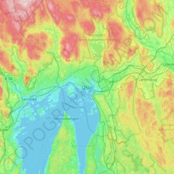
Name: Oslo topographic map, elevation, terrain.
Location: Oslo, 0026, Norway (59.75333 10.57897 60.07333 10.89897)
Average elevation: 610 ft
Minimum elevation: -3 ft
Maximum elevation: 2,093 ft
Make a donation
Gear up for your next adventure:
As an Amazon Associate, this site earns from qualifying purchases at no extra cost to you.
Other topographic maps
Click on a map to view its topography, its elevation and its terrain.
Make a donation
Gear up for your next adventure:
As an Amazon Associate, this site earns from qualifying purchases at no extra cost to you.
Akerselva
The Akerselva or Akerselven (English: The Aker River) is a river which flows through Oslo, Norway. It starts at Maridalsvannet in Oslomarka, and traverses the boroughs of Nordre Aker, Sagene, Grünerløkka, central Oslo and Grønland, finally ending at Paulsenkaien and Oset in Bjørvika. The river is…
Average elevation: 541 ft
Make a donation
Gear up for your next adventure:
As an Amazon Associate, this site earns from qualifying purchases at no extra cost to you.
Make a donation
Gear up for your next adventure:
As an Amazon Associate, this site earns from qualifying purchases at no extra cost to you.