Geolocate

Batad topographic map

Click on the map to display elevation.

About this map

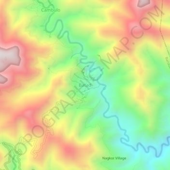
Name: Batad topographic map, elevation, terrain.

Location: Batad, Banaue, Ifugao, Philippines (16.91410 121.11627 16.95410 121.15627)

Average elevation: 3,488 ft

Minimum elevation: 1,903 ft

Maximum elevation: 5,243 ft

Other topographic maps

Click on a map to view its topography, its elevation and its terrain.

Banaue Rice Terraces

Philippines > Ifugao > Banaue > Viewpoint > Pan-ngat

Average elevation: 4,308 ft

Batad Rice Terraces

Philippines > Ifugao > Banaue > Batad

Average elevation: 3,291 ft

Banaue Rice Terraces

Philippines > Ifugao > Banaue > Viewpoint > Pan-ngat

Average elevation: 4,308 ft

Banaue Rice Terraces

Philippines > Ifugao > Banaue > Poblacion

Average elevation: 4,308 ft

Banaue Rice Terraces

Philippines > Ifugao > Banaue > Viewpoint > Pan-ngat

Average elevation: 4,308 ft

Gear up for your next adventure:

🏕️Tent Footprint - Protect your tent base from wear
🔋Rechargeable Batteries - Power up your outdoor devices
🪶Camp Gear Gift Set - Perfect gift bundle for outdoor fans
❄️Traction Cleats - Prevent slips on icy trails during winter hikes
📚USA Hiking Guide Books - Top trail guides and map books

As an Amazon Associate, this site earns from qualifying purchases at no extra cost to you.