
Thank you for supporting this site ❤️
Make a donation
Make a donation
Gear up for your next adventure:
As an Amazon Associate, this site earns from qualifying purchases at no extra cost to you.
Caranavi topographic map
Click on the map to display elevation.
Thank you for supporting this site ❤️
Make a donation
Make a donation
Gear up for your next adventure:
As an Amazon Associate, this site earns from qualifying purchases at no extra cost to you.
About this map
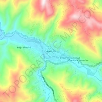
Name: Caranavi topographic map, elevation, terrain.
Location: Caranavi, Provincia Caranavi, LPZ, Bolivia (-15.87400 -67.60542 -15.79400 -67.52542)
Average elevation: 3,199 ft
Minimum elevation: 1,834 ft
Maximum elevation: 5,443 ft
Thank you for supporting this site ❤️
Make a donation
Make a donation
Gear up for your next adventure:
As an Amazon Associate, this site earns from qualifying purchases at no extra cost to you.