
Make a donation
Gear up for your next adventure:
As an Amazon Associate, this site earns from qualifying purchases at no extra cost to you.
Ulysses Township topographic map
Click on the map to display elevation.
Make a donation
Gear up for your next adventure:
As an Amazon Associate, this site earns from qualifying purchases at no extra cost to you.
About this map
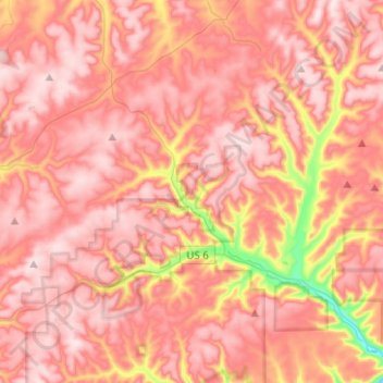
Name: Ulysses Township topographic map, elevation, terrain.
Location: Ulysses Township, Potter County, Pennsylvania, United States (41.72692 -77.84536 41.91322 -77.72391)
Average elevation: 2,218 ft
Minimum elevation: 1,352 ft
Maximum elevation: 2,608 ft
Potter County trails, hiking, mountain biking, running and outdoor activities
Make a donation
Gear up for your next adventure:
As an Amazon Associate, this site earns from qualifying purchases at no extra cost to you.
Other topographic maps
Click on a map to view its topography, its elevation and its terrain.
Make a donation
Gear up for your next adventure:
As an Amazon Associate, this site earns from qualifying purchases at no extra cost to you.
Harmontown
United States > Pennsylvania > Potter County > Genesee Township
Average elevation: 2,142 ft