
Make a donation
Gear up for your next adventure:
As an Amazon Associate, this site earns from qualifying purchases at no extra cost to you.
Melk topographic map
Click on the map to display elevation.
Make a donation
Gear up for your next adventure:
As an Amazon Associate, this site earns from qualifying purchases at no extra cost to you.
About this map
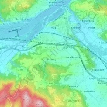
Name: Melk topographic map, elevation, terrain.
Location: Melk, Bezirk Melk, Lower Austria, 3390, Austria (48.18189 15.28644 48.24159 15.38383)
Average elevation: 932 ft
Minimum elevation: 663 ft
Maximum elevation: 1,841 ft
Make a donation
Gear up for your next adventure:
As an Amazon Associate, this site earns from qualifying purchases at no extra cost to you.
Other topographic maps
Click on a map to view its topography, its elevation and its terrain.
Make a donation
Gear up for your next adventure:
As an Amazon Associate, this site earns from qualifying purchases at no extra cost to you.
Persenbeug
Austria > Lower Austria > Bezirk Melk > Gemeinde Persenbeug-Gottsdorf
Average elevation: 856 ft